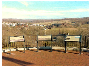
 The hills overlooking Mine 40 provide a unique opportunity to appreciate how the lives of the miners and their families and the operations of the coal companies were so intimately tied together. The ECHF took advantage of this opportunity by contructing an overlook park of about one and one-half acres with interpretive displays explaining the various parts of the vista available for viewing.
Visitors can see the remains of a major drift coal mine and gain a better appreciation of the magnitude and kinds of operations necessary to keep such an enterprise going. Alongside the mine is a typical 'coal patch' town consisting of about 100 wooden duplex houses built by the company to house its workers. The remains of a huge 'boney pile', a man-made mountain of stone/coal discard provides a dramatic backdrop to the view. Interpretive displays provide a history of the area, show the purpose of the mine structures, and provide graphic views of the layout of underground workings of the mine, which encompass several square miles of tunnels and linkages to other entrances in the area. The Mine 40 Overlook is located at the intersection of Main Street and Richland Avenue in Scalp Level, PA., on old State Route 56. (40.2520N, 78.8460W) 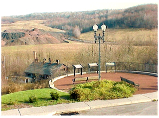 Although the Mine 40 overlook project was included in the America's Industrial Heritage Project, site location and design planning began in 1989 with a $20,000 state grant provided by Rep. Leona Telek, R. 70th District. The initial cost estimate for the project was $212,000. Although the Mine 40 overlook project was included in the America's Industrial Heritage Project, site location and design planning began in 1989 with a $20,000 state grant provided by Rep. Leona Telek, R. 70th District. The initial cost estimate for the project was $212,000.The ECHF bought the property at 305 Main Street, Scalp Level, PA in May, 1990. This lot, along with approximately one acre of surrounding land donated by the Berwind Corporation, provided the base for constructing the Overlook. Design planning continued as planned until an error in elevation made by the design engineer necessitated a re-evaluation of the design in November, 1991. An extensive historical and archeological study of the site was conducted by the National Park Service in July, 1992. They found no evidence that the house was constructed by the Berwind-White Coal Company, or any other association with the mine other than the house was occupied for 12 years (1937-1949) by a Berwind-White mine supervisor. There was some indication in a 1867 map that the property was the site of a toll house on the state highway through the area. In March, 1992 the ECHF conveyed the deed for the 1.467 acre parcel to Scalp Level Borough to make it eligible for grants that otherwise could not be requested. In December, the ECHF and the Borough signed a 25-year agreement for operation and maintenance of the Overlook, whereby the ECHF will maintain and operate the site as a scenic overlook. Construction of the Overlook was completed in June, 1993, and it was immediatly was opened to the public. Installation of the final interpretive displays was completed in June, 1995. Final project cost for the Overlook included: Construction - $129,558; Property acquisition - $27K; Berwind property donation - $15K; Architect fees $12,995, for a total of $184,513. |
|